I needed to figure out how to get my solar panel cables from the outside of the car to the inside. Drilling a hole wasn’t an option, so I had to figure something else out. (Click here if you can’t see the video below.)
LINKS
I needed to figure out how to get my solar panel cables from the outside of the car to the inside. Drilling a hole wasn’t an option, so I had to figure something else out. (Click here if you can’t see the video below.)
LINKS
This is the second video from my monthlong SW United States road trip. I check out some cool rock formations (including an arch you can drive right up to) and some really stellar Native American rock art. I also almost get stuck and nearly freeze to death. Good day. (Click here if you can’t see the video below.)
GPS COORDINATES
** Pinnacle Peak: 39.594173, -110.888184
** Rochester Rock Art Panel trailhead: 38.9066, -111.1953
** Rochester Rock Art Panel: 38.9031, -111.1980
** Dutchman Arch: 38.8724, -110.7876
** Pictograph Panel #1: 38.8800, -110.7652
** Pictograph Panel #2 (the better panel): 38.8809, -110.7709
** Campsite: 38.854283, -110.798166
GEAR FROM THIS VIDEO
** Traction mats (Amazon affiliate link)
** Shovel (Harbor Freight link)
** Small table (Amazon affiliate link)
** See a list of all of my gear here
OTHER LINKS
** Kamchatka Gear (My online store)
** SUV RVing the Book (Amazon affiliate link)
** Instagram
** FKB.me (My free Kindle book website)
In this video I finally head out on the road for the first time since my hip surgery. I make it to the high desert in central Utah and enjoy a couple of desert waterfalls before calling it a day at a great secluded campsite. (Click here if you can’t see the video below.)
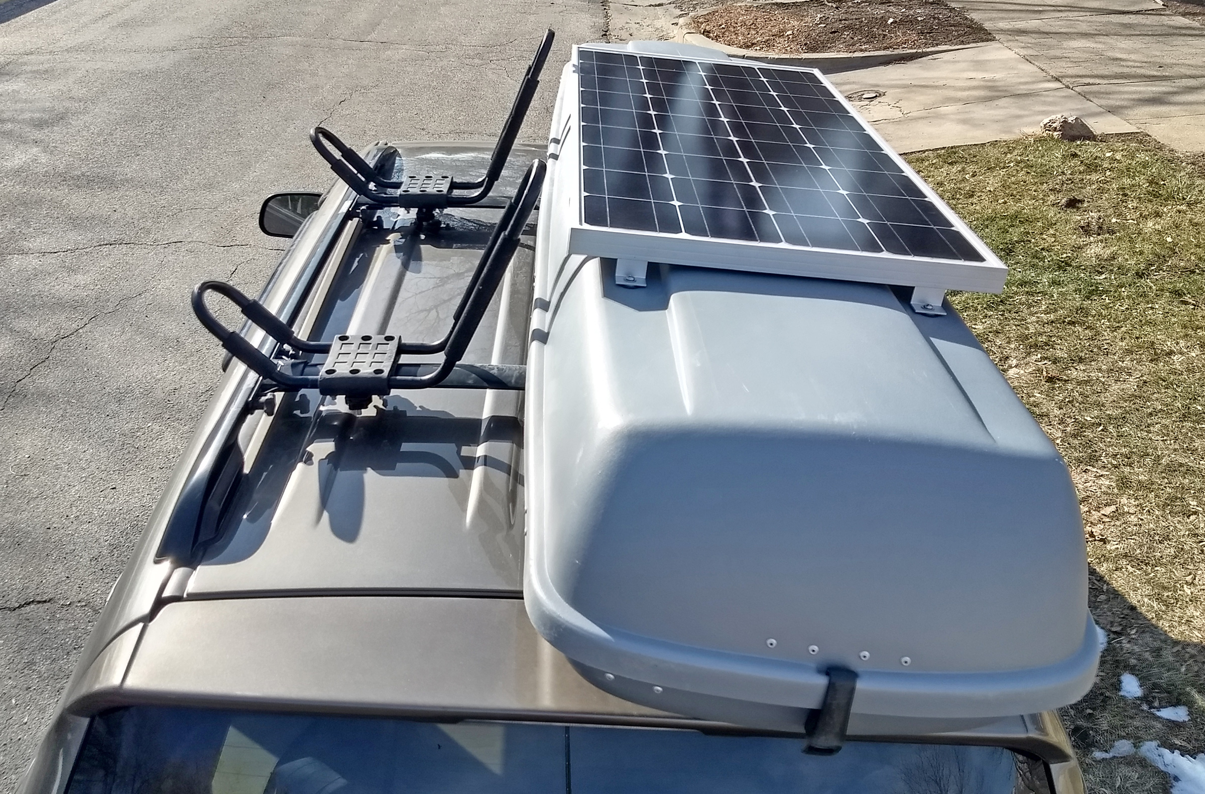
In this video I go over how and why I mounted my 100-watt solar panel to the rooftop cargo box (car top carrier) on my RAV4. I didn’t know if this would work, and some of the viewers on the YouTube channel also shared their doubts and skepticism with me, but I’m happy to report that it works perfectly. (Click here if you can’t see the video below.)
This video is my step-by-step guide to building a portable solar “generator” for camping, basic off-grid living, etc. It’s basically a self-contained ammo can-style setup (i.e., a lot of people build something like this using an ammo can/box), but my batteries are larger than what I could fit into an ammo can, so I had to upgrade to a larger box. I use it to power my laptop, charge camera batteries, run a fan, and charge my phone and tablet. (Click here if you can’t see the video below.)
The video is the main thing, but the information below the video here is supplemental to help you out.
I am not an electrician. I basically have no idea what I’m doing, but I was able to successfully build a solar setup that works well so far. Follow these instructions at your own risk. You’re on your own here. Don’t blame me if you mess something up, break something, or hurt someone.
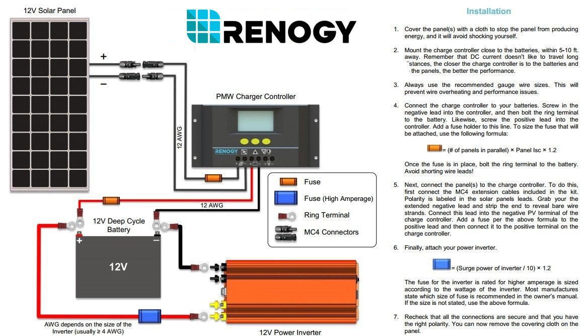
This is the diagram/schematic that I followed (click it for larger version). I recommend printing it out:
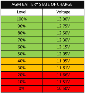
And then this is the battery charge percentage chart that I reference in the video.
These are the components I used, and I’ve included links to the products on Amazon or Walmart.com as appropriate. (Note that most of these are Amazon affiliate links, and I’ll get a small commission if you buy them or something else from Amazon through the links.)
****TOTAL: $390*****
I won’t go into a TON of detail here because I do that in the above video. But just as a reference point, here are the steps I went through to create my portable solar setup:
1. Gather materials.
2. Cover solar panel with towel.
3. Mount charge controller.
4. Cut a bit of the plastic off of the lip of the side of the box.
5. Mount the inverter.
6. Cut the 15′ solar cables down to size (10 ft).
7. Cut a ~13″ piece of the black cable from the 5-foot piece just cut off.
8. Strip the ends of the 13″ black piece and one of the red fuse holders.
9. Add a ring terminal to one end of the 13″ black piece and the red fuse holder.
10. Drill a wire passthrough hole just below the charge controller.
11. Plug one end of the 13″ black piece into its respective terminal/socket on the bottom side of the charge controller.
12. Attach the other end of the 13″ black piece (the end with the ring terminal) to the negative side of the battery.
13. Repeat steps 11 and 12 with the red fuse holder.
14. Cut off another ~13″ from the end of the red solar cable and strip the end of the remaining solar cable.
15. Strip both ends of another one of the red fuse holders and strip the end of the long black solar cable.
16. Use a butt connector to join the red solar cable and the red fuse holder.
17. Connect the stripped ends of the long solar cables to their respective terminals on the underside of the charge controller.
18. Plug the long solar cables into the solar panel.
19. Attach the 12-volt cigarette lighter plug socket thing to the battery terminals.
20. Attach the inverter cables to the inverter after drilling a hole for the cables to go through.
21. Connect the inverter to the battery by plugging the inverter’s cable into the 12-volt socket .
22. Uncover the solar panel.
23. Test everything to make sure it works.
Last month I met up with Chris from the YouTube channels Tiny Home Tours and Chris and G Travels. He did a very complete tour of my SUV camping setup, and it’s embedded below (or you can check it out here on YouTube if you can’t see the video below). Let me know if you have any questions!
In this video I talk about a handful of things to keep in mind or consider when looking for a dispersed camping campsite out in the boonies (aka boondocking). Let me know what other things you look for in a good boondocking spot. Also, sorry for the weird camera focusing issues. My camera may be broken… (Click here if you don’t see the video below.)
In this video—the second of a two-part series of a two-day trip I went on—I continue to explore some extremely remote and rarely visited areas in the desert west of Salt Lake City, Utah. I promise you haven’t seen this stuff before. (Click here if you can’t see the video below.)
This is the first of a two-video series of a two-day trip I did last November. The goal was to visit some very obscure places that are surprisingly close to civilization, and it was probably the best 2-day trip I’ve ever done. (Click here if you don’t see the video below.)
This video contains footage from two big dayhikes I went on a week apart in September 2017. Both hikes involved climbing a couple of the 11,000-foot peaks in northern Utah’s Wasatch Mountains. These were very long days in some of the most beautiful mountains in Utah. The scenery is incredible. Enjoy! (Click here if you can’t see the video below.)
Stats: ~11.8 miles round trip with 5,000 feet of elevation gain
Stats: ~13 miles round trip with 7,600 feet of elevation gain